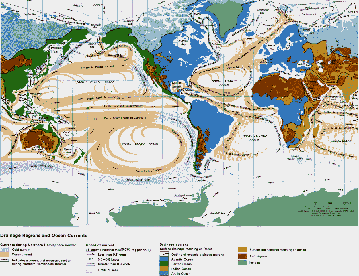
Labels:map | text | atlas OCR: ARCTIC OCEAN West Spitsbergen Greenland Current 'East Spitsbergen Current' Laptev Sea Baffin Sea Barents Sea Kara Sea East Siberian Coastal Current East fin Istand Current Siberian Bay Beaufort North Cape Current. Yamal Current-4 Novaya Zemlya Current Chukchi Sea Norwegian Sea Chora Current AMMurman Current mien White Bering Current! East Greenland Current Norway Current Hudson Sem Bering Bay abrador Current & Labrador', Irminger Cup North Okhotsk Anadyr Current " Alaska Current Sea Ser Se Subarctic Current Aleutian Current Bay of BIScay k Sea Ova Current North Atlantic Current -> +++North Pacific Current California Current Azores Current Labrador Extension Mediterranean Sea China the Gulf Stream Current NORTH PACIFIC OCEAN Gulf of Antilles Current NORTH ATLANTIC Mexico mid- Atlantic North Equatorial Cuff foride Current OCEAN nary Current Kuro Current Caribbean South Philippine DAbbean zwang Carmen the South Equatorial wulfen, China Son --- Pacific North Equatorial Current Arabian + Sea Benc ¡Celabes --- 4 Atlantic Equatorial Countercurrent : Laccadive. Pacific Equatorial Countercurrent PAP Monsoon 17 Sea. Guinea Current Drift Banda Indian Equatorial Counterel Sta Solomon Pacific South Equatorial Current - Sea Ses peru (Humboldt)( East Austinna Currant ux Last Africa Coastal Current Benguela Current Indian South"Equatorial Curre Mentor Current Coral Se SOUTH ATLANTIC Brazil Current OCEAN INDIAN OCEAN !! urant trent SOUTH PACIFIC OCEAN - - Great -South Indian Current Australian tr Tasman Agulhas Bight w West Australie Current Ses South Atlantic Currently- Corrent Current West Wind Drift West Wind Drift South Pacific Current Cape Horn Current West Wind Drift Bellingshausen Amundsen Sea Sea 1000 3000 Jules - 1000 2000 3000 4000 kilometers Scale (approx ) 1.126.000.000 1 inch equals 1.975 miles - Ross Sea Weddell Ses Miller Cylindrical Projection Truk scale only on the Equator Drainage Regions and Ocean Currents Currents during Northern Hemisphere winter Speed of current Drainage regions Cold current (1 knot=1 nautical mile[6,076 ft.] per hour) Surface drainage reaching an Ocean Surface drainage not reaching an ocean Warm current 1 Less than 0.5 knots Outline of oceanic drainage regions Arid regions Indicates a current that reverses direction 0.5-0.8 knots Atlantic Ocean during Northern Hemisphere summer Greater than 0.8 knots Pacific Ocean Ice cap Limits of seas Indian Ocean Arctic Ocean